Monday, January 19, 2015

Section 106 review for a rural historic landscape: Elsinboro and Lower Alloways Creek


A new nuclear plant is proposed for the Artificial Island site in Salem County, where three reactors and a cooling tower already exist.This is hard to imagine in the light of what happened at Fukushima, but nevertheless, PSEG has put in an application for an early site permit, which is essentially a site plan review. It's a first step, and if granted, the permit is good for 20 years, within which time the utility may or may not actually build it. And further permits are needed, such as for the specific reactor design. So what would earn this a place in my blog on researching the cultural landscape of Down Jersey?

View of the Salem Nuclear Plant at Artificial Island from Mason Point

The reason is that the project requires a permit from two Federal agencies: the Nuclear Regulatory Commission and the Army Corps of Engineer. Therefore, the approval process triggers a review under Section (106) of the National Historic Preservation Act. Potential impacts of the undertaking on properties listed or eligible to be listed on the National Register of Historic Places must be taken into account, and either avoided with alternative designs or mitigated with benefits to the public. The agency handling the Section 106 is the New Jersey Historic Preservation Office (SHPO).


On the surrounding landscape, there are a number of such properties, mostly in Elsinboro township, but also in Lower Alloways Creek Township, both lying along the Delaware River. Two kinds of effects have been identified so far.  One is the visual effects of two new cooling towers on this, flat, rural landscape. Another is the effect of the construction and use of a new, three lane highway running north from the Island across tidal marsh up to and following Money Island Road. The new cooling towers will stand next the existing one but rise 40 feet higher. The roadway will run on a 48' wide elevated causeway over the tidal marsh and a 200' right-of-way on Money Island Road, requiring considerable widening of this quiet back road and possibly the addition of other structures such as a drainage system, guiderails, and signals where it would terminate at Mason Point Road. Such structural and operational changes will drastically alter the landscape experience at Mason Point. The increase in daily traffic during construction and during future daily commuting of Island workers is another thing that will change daily life in Elsinboro--noise, fumes, safety--a general disruption of the daily peace in this sleepy township.

Proposed access road from Artificial Island to Mason Point.


Whether or not this scenario will actually happen is a big IF, but if it does, the review process is a powerful way to influence the outcome. Mitigation measures will be negotiated between the SHPO and PSEG. This could result in benefits to or for historic properties that would otherwise not happen. In addition, because the Abel and Mary Nicholson House is a National Historic Landmark, a higher level of review is required and perhaps more extensive mitigation.

I was given "interested party" status for the Section 106 review. I expressed concern to the staff at the New Jersey Historic Preservation Office after the project came to my attention and I read through the Early Permit Draft Environmental Impact Study (http://www.nrc.gov/reading-rm/doc-collections/nuregs/staff/sr2168/index.html). It seemed to me that some resources and impacts were overlooked. So I ended up getting invited to a meeting of PSEG, Nuclear Regulatory Commission, and SHPO representatives on January 9.

So, now, the fieldwork! Yes, there was fieldwork. After discussing the permitting process (which is quite complex) we took to the road and visited eligible and potentially eligible properties that came to light during the review. Three of the five were properties we saw were ones I suggested. Four were not initially detected in PSEG's DEIS. The purposes of the visits were to help the SHPO determine eligibility and to assess the visual affects of the new towers from each. This review has a ways to go before it's done. If any readers have information to share on these houses, please let me know by leaving a comment below. Thanks.

John Goodwin Mason-Edward Waddington House, built in the late 18th century, and presently used as PSEG's field office for education and outreach. It would fall within or very near the access road right-of way.
Sarah Mason House on Fort Elfsborg Road, Italianate with a pattern-brick core. Cooling tower is seen left of center.

Morris-Goodwin House, next door, despite modern cladding, dates from the mid-18th century with a log house core and a pattern brick shed addition. It was recorded  by HABS in the 1940s.

Abel and Mary Nicholson House, a National Historic Landmark built in 1722. It was preserved during the PSEG Estuary Enhancement Project in the 1990s.

John Denn House on Poplar Street in Lower Alloways Creek, built 1725.

116 Mason Point Road, probably built late 18th century, and possibly related to the Mason family.

View of the cooling tower from 116 Mason Point Road.

View from 116 Mason Point Road to the John Mason House, built 1695/1704. There, the access road would terminate.

Tuesday, October 28, 2014

Outreach follows Fieldwork

Once the fieldwork is done, drawing, photo editing, and writing ensue. Often furiously, to make a deadline (hopefully). Then I spend time distributing the products around the state and region, in hardcopy and electonically. Then, I find, after awhile, opportunities arise to share the new knowledge gained in a more personal way. Slowly, as people read my products, they learn and show appreciation. I get phone calls from descendents of Reuben Cuff, and Marshalltown folks or from ghost hunters wanting access to a (hopefully) haunted building. I get invited to speak, to share the findings "live." Or I propose a conference paper. It's important to get the findings out there, to share the knowledge learned.

This year alone, I will have given three paper presentations. The first was on Marshalltown at the VAF conference in May. The editors of VAF's journal, Buildings & Landscapes, want an article from me based upon this paper. The Marshalltown research began with a survey grant in 2009, followed by a grant to support the National Register listing in 2011, both from the NJ Historical Commission.


I had given a version of this at the 2012 NJ Historic Preservation Conference:


This month, I was honored to be the 11th John Rock Lecturer for the Salem County Historical Society in Salem. I talked on Reuben Cuff, whose house was the subject of  my first NJ Historical Commission grant in 2008. 


It was an expanded, updated version of a presentation I gave at the 2012 New Jersey Forum.


Next month I will again share the story of Marshalltown to the Council of Northeast Historical Archaeology at their annual conference in Long Branch, NJ.


That one will culminate in a chapter in a proposed book called Seated at the Same Table: Archaeologies of African American Life in the Upper Mid-Atlantic, edited by Michael J. Gall and Dr. Richard F. Veit, and published by the University of Alabama Press.

Slowly, the doors open.

My farmstead study of 2013-2014 will be the next outreach effort. In the meantime, I'll figure out my next fieldwork project...

Postscript: Speaking of fieldwork, I neglected to mention another presentation I gave in June. With my associate Maria Cerda-Moreno, I gave a workship on recording buildings at the New Jersey Historic Preservation Conference. We are hoping to do more of this!


Tuesday, October 14, 2014

Fieldwork Past Presented to the Public

On Sunday, October 19 I will be honored to be the 11th John Rock Lecturer. Please attend! 

This research was initiated in 2008 and funded by my first grant from the New Jersey Historical Commission.


Wednesday, September 10, 2014

Farms Finis.


The Salem County Farms Recording Project is now complete! That is, this grant project is complete. I hope to continue recording farms in Down Jersey in the future. I have only scratched the surface, and there is so much more to discover and preserve.

The report is available here for reading and download. It includes 29 drawings of farmhouses and outbuildings in addition to the narrative descriptions and history on the NJ SHPO survey forms.

If you want to order a printed copy of the report (it's 163 pages), go here.

The drawings are available by themselves as 24x36 inch drawings:
Wyatt Farm
Wistar Farm
Watson Farm


This project was assisted by a grant from the New Jersey Historical Commission, a division in the Department of State, State of New Jersey, a Fieldwork Grant from the Vernacular Architecture Forum, and an in-kind match of services from the Center for Historic Architecture and Design, University of Delaware. Thank you, funders!

Tuesday, August 6, 2013

Survey and Photography: Illuminations

Early to mid-June was taken up by the excellent VAF conference in Gaspé, Quebec. Back in Salem County on June 17, I set the drawing work aside to get back to each farm and get my head wrapped around each building and each farmstead by looking at them in detail. I surveyed room-by-room, taking notes on materials, workmanship, finishes, hardware, and clues about alterations and the evolution of each house and barn. Instructed by the survey and by the drawings before that, I went back for a round of careful photography to record the important features and views I had observed.

After eleven buildings, I set to work writing the narrative and found myself up against my deadline of July 31 with no chance of finishing. In typical form, I requested and received a grant period extension from the folks at the New Jersey Historical Commission, my funding agency.

But the good news is...I've discovered some really interesting stuff in these farmhouses and barns. The barns are really surprising me with their age. Two of the farms have barns that were born in the time when carpenters were hand-hewing timber frames, then grew in a variety of ways in response to changes in agriculture and the economy. That gives us a good opportunity to look at changes in farm buildings over a long period of time, knowing that hewing frames was the earliest method of cutting wood. Sawmilling may not have been available or near enough to the site for economical use, or the technology was not yet used for cutting posts and beams. So, these hewn frames could represent the earliest period of the farmstead. Subsequent alterations would reflect changes in farming on the particular farms as well as the larger agricultural context in which these farms existed.

Triangle Farm in Aldine


The hewn frames at Triangle farm include the house, part of one large barn, and a crib house. Considering everything I saw in the house, particularly nails and hardware, I think it was built between the Revolutionary War and 1800. If so, it may be that the two outbuildings were built in the same period, all as the establishment of a new farmstead. The finishes in the house are simple and lack of paneled doors typical of more elite houses, and so may signal a tenant house, especially since before 1817, this farmstead was on a 300-acre parcel known as the "Gamble Farm" on which was a pre-Revolutionary War pattern-brick house which would have belonged to the landowner. Sometime before 1749 William Gamble of Dublin, Ireland had purchased a large tract in Salem County. Left to his son, John, and then to John's son William, this land was occupied by several tenants, as noted in a newspaper notice to them in 1762.

The house today represents an evolution that continued through the first half of twentieth century. Initially a two-story house with a one-story step-down kitchen, with the facade of each section fenestrated in three symmetrical bays, the purchase by John and Rachel Watson in 1830 seems to have triggered the raising of the kitchen wing into two stories with an entire new sawn frame, and the redecoration of the main parlor in up-to-date Grecian-profiled millwork.


Watson was a miller who in 1826 had just completed the construction a saw mill nearby, owning the mill and the mill pond property with a partner. The Watson's purchase of this house may have been driven by the mill venture, and their need to reside nearby. One John A. Watson who was this John Watson's father was a shipbuilder in Alloway village held interests in two schooners when he died. The sawmill may represent an enterprise to exploit the abundance of uncleared forests in eastern Alloway Township and lower Pittgrove in the early nineteenth century to provide materials for shipbuilding and other local uses, as well as for export. The rebuilding and remodeling of the house may reflect Watson's socio-economic status as an industrialist and trader, and/or an inheritance upon the death of John A. Watson in 1838.

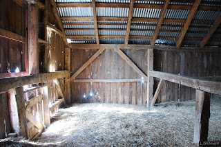
The milking barn was structured as a three-bay English type, which is characterized by a central drive-through bay where hay from the field was unloaded and stored in the adjacent mows, and where the wood floor was used for threshing grain. A small number of horses, oxen and milk cows were probably keep there as well, as work animals. Though Watson was a miller, he, like most people, farmed for both family subsistence and may have participated in market trade that was growing in that period.

Gable-end of the Milking Barn

West end of milking barn showing hewn framing of the original English barn.

The barn was extended by sixteen feet with sash-sawn joined timbers. It is likely that John Watson, who occupied this farm from 1830 to his death in 1864 is responsible for this extension and the replacement and relocation of rafters for the entire barn. The timbers were probably sawn in Watson's Mill. There is no evidence that this extension had a drive -through bay, so it may have been primarily for the housing of a larger collection of animals.

The next stage was the addition of a two-level shed on the long side, which may have been built for additional hay storage above and either animal pens or a milking area on the first floor. Its circular-sawn timbers and nailed braces suggest a late nineteenth-century period, perhaps that of William Simpkins, a miller and blacksmith who married Watson's daughter Jane and acquired the farm in 1869.

Upper level of shed addition
Lower level of shed addition
This became the milking parlor that exists today, possibly in the early twentieth-century when Herbert and Hattie Smith were the owners. When the state began regulating milk production and hygiene on farms, the present setup of metal stanchions, concrete floor and whitewashed interior was installed. These stanchions could date from the 1920s. It seems that in that period also, the "calf barn" was added at right angles to the main barn. It does not appear that the calf barn ever had a drive-through bay like the early barn, but always penned animals and provided extra space for milking below and hay storage above.

Calf barn

Upper level of calf barn
Lower level of calf barn
There is one more farm outbuilding that dates from an earlier period. The "wagon shed" was a drive-through corn crib, or crib barn. It is closer to the house, and also has a hewn timber frame, except for the sash-sawn floor joists.

Crib barn

The cribs were dismantled, but the mortise pockets for stud wall on both sides of the barn allow us the"read" the cribs on both side walls that were used to store corn cobs to feed animals. Like the other barns, much of the first floor framing and cladding has been transformed to concrete block, as weather and rot took its toll on old sills and posts. But enough remains to allow a reading of the original design and use.

Hewn corner post in crib barn


Joists in crib barn showing robbed mortises of the wall studs of the crib